


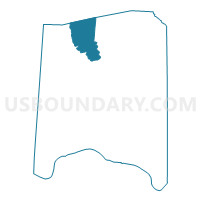
TRANQUILITY Voting District, Adams County, Ohio
About
Outline

Summary
| Unique Area Identifier | 642431 |
| Name | TRANQUILITY Voting District |
| County | Adams County |
| State | Ohio |
| Area (square miles) | 25.13 |
| Land Area (square miles) | 25.13 |
| Water Area (square miles) | 0.00 |
| % of Land Area | 100.00 |
| % of Water Area | 0.00 |
| Latitude of the Internal Point | 38.98631760 |
| Longtitude of the Internal Point | -83.53578870 |
Maps

Graphs
Select a template below for downloading or customizing gragh for TRANQUILITY Voting District, Adams County, Ohio


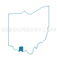
Neighbors
Neighoring Voting District (by Name) Neighboring Voting District on the Map
- BRATTON TOWNSHIP Voting District, Adams County, OH
- Voting District CONCORD, Highland County, OH
- Voting District JACKSON, Highland County, OH
- JACKSONVILLE Voting District, Adams County, OH
- OLIVER TOWNSHIP Voting District, Adams County, OH
- SEAMAN PRECINCT, Adams County, OH
Top 10 Neighboring County Subdivision (by Population) Neighboring County Subdivision on the Map
- Meigs township, Adams County, OH (3,905)
- Scott township, Adams County, OH (2,180)
- Bratton township, Adams County, OH (1,461)
- Concord township, Highland County, OH (1,415)
- Oliver township, Adams County, OH (1,319)
- Jackson township, Highland County, OH (1,094)
Top 10 Neighboring Unified School District (by Population) Neighboring Unified School District on the Map
- Adams County/Ohio Valley Local School District, OH (24,029)
- Bright Local School District, OH (4,960)
Top 10 Neighboring State Legislative District Lower Chamber (by Population) Neighboring State Legislative District Lower Chamber on the Map
- State House District 88, OH (122,323)
- State House District 89, OH (120,820)
- State House District 86, OH (114,338)